Our monitoring system

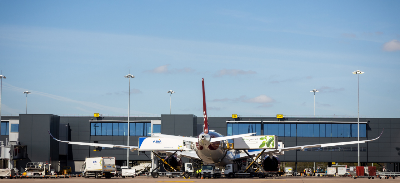
Environmental management and reporting is essential for sustainable airport operations. This allows the airport to understand its impact on the local environment and communities, and what can be done to manage and mitigate those potential impacts.

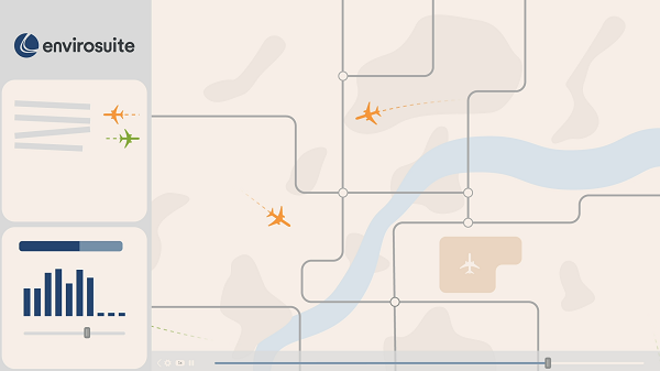
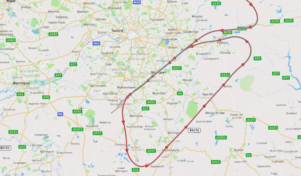
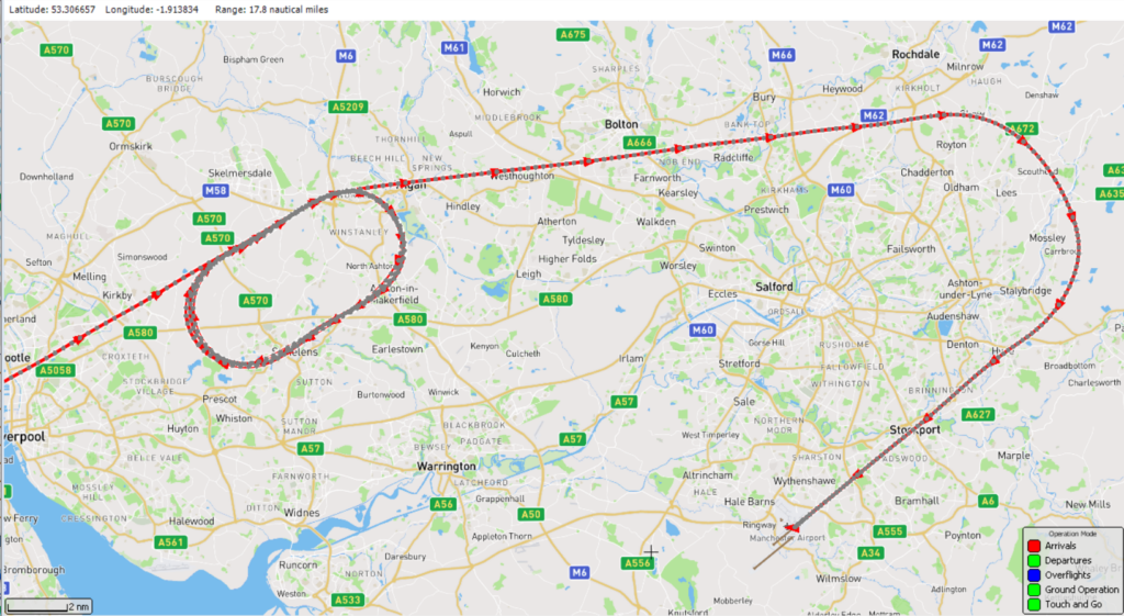
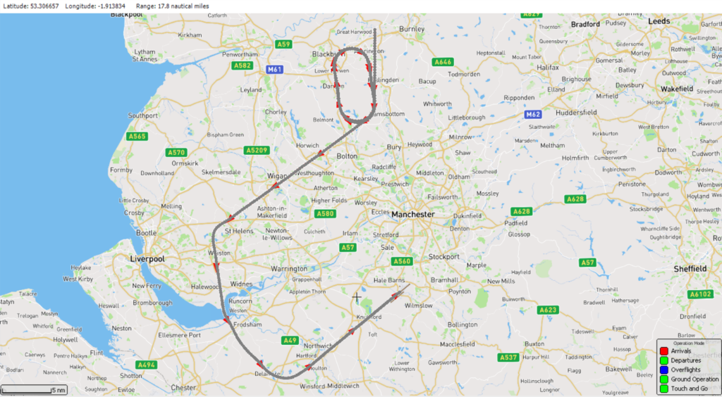
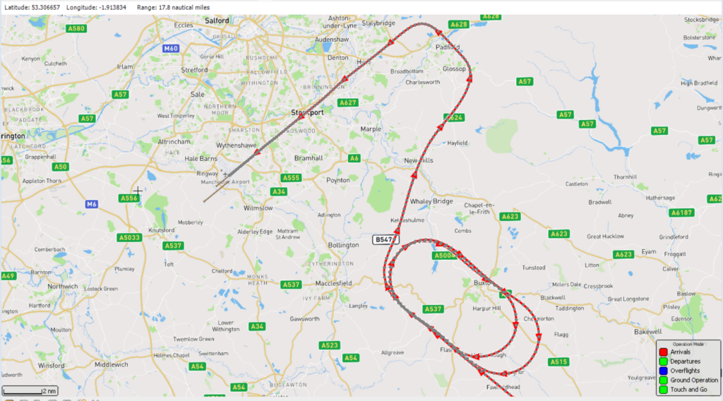
The system Manchester Airport uses is called ANOMS, which stands for Airport Noise and Operations Monitoring System. It is a complex solution featuring both hardware in the form of remote sensors, radar data collectors as well as advanced analytical tools.

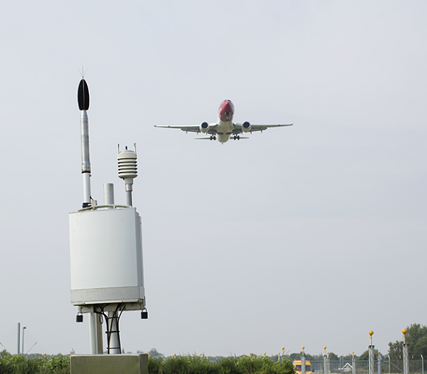
ANOMS uses a number of fixed or temporary noise monitors in the local area, these are generally located under or near flight paths. The monitors detect and record the noise levels 24 hours a day, 7 days a week to a central system.

You can find out more by watching this video:

Data collection and noise event detection

The system combines data from remote noise monitors deployed in the local community and in proximity to runways and flight paths. These run 24 hours a day 7 days a week, continuously collecting and sending noise data through to ANOMS, creating ‘noise events’ when the noise level rises above the background noise level and meets pre-set thresholds.

An aircraft overflies a noise monitoring terminal

Flights are tracked using data direct from Air Traffic Control (ATC) radar systems, in effect it is the same data used by ATC to safety control aircraft in the sky. ANOMS uses this data to record the path flown by the aircraft and by identifying which noise monitors the aircraft flew close to and when. ANOMS then identifies which aircraft generated each of the noise events.

The process is complex and whilst it can identify noise events due to aircraft it can also identify events that were not generated by aircraft. These are known as community events and could be generated by birds, wind, vehicles on a road or even emergency vehicle sirens. In effect, any noise that we could hear on a day-to-day basis that isn’t generated by an aircraft.

By considering the aircraft and community noise, a detailed picture of the local soundscape can be built, allowing the airport to understand the potential impact of operations in the local community.

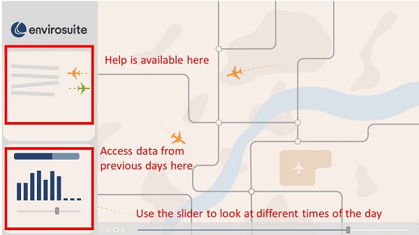
How the system is used

The ANOMS system is used by different stakeholders in the airport management structure:

  • Our Flight Evaluation Unit team can view enquiries, complaints and submissions from the local community. Accessing the detailed data available within ANOMS to respond to the local community. This includes detailed weather and operational data to explore and analyse unusual operations.
  • Operations teams can use the detailed reports to assess and continuously improve the airport.
  • Management can assess trends, determine performance and provide direction.

In summary, the system allows us to quickly identify and analyse anything anomalous, and also monitor the day to day operations of the airport, presenting reports to aviation stakeholders and the community. The historical data can then be used to plan for the future and improve operations, where possible.

You can find out more by watching this video:

How high are flights in my area?

How high are flights in my area?

The altitude of aircraft can vary due to a number of factors. It could depend on which airport the flight is going to or from, and whether it is an arrival or departure. Arrivals are typically following a steady descent to the runway whilst departures are typically following a steeper path as they climb away from the runway.

A core function of Air Traffic Control (ATC) is to maintain the safety of aircraft operations at all times, and one of the primary ways in which this is achieved is by maintaining either horizontal or vertical distances between aircraft. This chart shows the height of aircraft overflying your area in 1,000ft increments. Hover your mouse over it for more figures and details. A dropdown menu allows you to view historical months for comparison and trends. The data is refreshed monthly, generally in the middle of the month.

How frequent are flights in my area?

How frequent are flights in my area?

There are a number of factors that influence the frequency of flights:

  • The number and frequency of flights will vary on a daily, weekly, monthly, and yearly basis due to differences in airline schedules. The airlines schedule flights in response to consumer demand. This is particularly the case around holiday periods.
  • The runway in use at any given time will also vary, largely due to the wind conditions. The runway can operate in an Easterly or Westerly direction. Each runway direction has its own set of flight paths, and each flight path will affect different areas. As the runway in use changes, the flight paths change, and so do the areas affected.

This chart displays the average number of flights per day of the month or per hour. Use the toggle to switch between the graphs. Hovering your mouse over the chart shows more details, with historical months available via the dropdown. The data is refreshed monthly, towards the middle of the month.

Noise Data (All Areas)

General Noise

Most us experience a variety of sound on a daily basis. According to the Cambridge Dictionary, noise is defined as a sound that is unwanted, unpleasant, or loud.

Noise is not only about how loud the sound is. There are a complex set of factors that drive annoyance both based upon the noise itself and what that noise means to us. A dripping tap is mostly quiet, but it’s repetitive beat can be annoying. A mosquito’s buzzing is also quiet, yet it is high pitched.

Sounds rarely occur in isolation. It is when we build a combined picture of all of the day-today sounds such as traffic and wind, that we start to identify noise. Certain noises, such as a siren, can be easily heard above the day-to-day sound. Other noises may only be heard when the background level is lower, such as during the night. These principles also apply to aircraft. Whilst the sound level will vary depending on your location, what that sound means to us individuals will drive our response to the resulting noise.

Manchester Airport Noise Data

To understand the noise impact on the local community, the airport has a number of fixed or temporary noise monitors deployed in the local area, generally under or near flight paths. The monitors detect and record the noise levels 24 hours a day, 7 days a week to ANOMS.

A ‘noise event’ is created when the monitor detects noise exceeding the background or local noise level for a noticeable amount of time. This could be due to any number of factors, be it nearby birds, cars or an aircraft. By continuously monitoring the noise level and integrating data from Air Traffic Control (ATC) our systems work to determine if the noise event was generated by an aircraft, or another source. Only events reported as aircraft noise events are reported in our statistics.

The data collected by all of our fixed noise monitors is presented in the dashboard below.

Choose a noise monitor location in the top left hand corner to get started. See our ‘How we manage noise’ page here for more information about noisy aircraft penalties. Please note you will be directed away from the “Your Area” heading. A number of our noise monitors positioned directly below the flight path are used for fining aircraft on departure and the noise limits are calibrated with respect to the height and distance of the runway to the monitor location.

The dashboard is automatically updated every month and you can access data from previous months using the drop-down. A comprehensive list of aircraft types can be found here.

Find a particular flight

Introduction

WebTrak is our online flight tracker which provides the aircraft flight number, aircraft type, its height and track.

We also show aircraft which do not operate from our airport. You can see aircraft arriving and departing, sometimes in a holding pattern, operations from other airports nearby, as well as the data direct from our fixed and mobile noise monitors.

WebTrak uses data taken directly from air traffic control (ATC) radar, this is the same data that ATC use to safely manage aircraft in the sky. It is fed directly into the Airport Noise Monitoring and Management System (ANOMS) which powers the flight tracking systems.

Please note: A delay of up to 6h is applied to the replay of ‘live’ data to ensure all data is presented as accurately as possible.

How to use WebTrak

Showing where the help can be found (top left) in webtrak, where historical data can be found (bottom left) and how to move time (slider at bottom)

WebTrak, allows you to both investigate flights above your area in near real-time as well as investigating historical data. There is lots of online help contained in the tool (available through the menu on the left hand side of the screen) to help you understand the icons and method of operation. But to summarise some of the key features, you can:

  • Investigate a specific flight that might have caused a disturbance,
  • Investigate flights from the the busiest part of a day,
  • Discover where a flight was going or where it came from
  • Analyze the proximity of flights to your location by dropping a pin on the map.

Sometimes the tool will display flight routes or rainfall layers. These sorts of overlays provide a great visual tool for analysing flight corridors or understanding adverse weather.

You can also make a complaint about the flight, which will be sent through to us for review. This method helps us because we can immediately identify the aircraft that caused the disturbance.

I can’t see the flight that disturbed me

Webtrak takes a feed directly from Air Traffic Control (ATC) and whilst we aim to display all flights, you may notice that some are missing. This could be due to a number of reasons including:

  • If it was a military, police or civil protection flight
  • If the aircraft was carrying a Government Official or Head of State
  • If the aircraft was operating to/from another airport

Typical flight paths

Arriving and Departing Aircraft

Every major commercial airport typically has set flight paths for departing aircraft from their runways. These are in place to maintain safety and whilst safety is always the number one priority, these routes are designed to minimise environmental impacts as much as possible in terms of fuel burn, emissions and noise impacts. However, airspace congestion and local weather, such as thunderstorms, may result in a large spread in flight paths. Arriving aircraft follow broadly similar patterns, which are not as defined as the flight paths for departing aircraft. Aircraft are directed by ATC to a position where they turn onto a runway heading (the direction of the runway that the aircraft will land on) before making its final approach. At Manchester Airport there is an Instrument Landing System (ILS) that guides the airport during its final approach to the runway.

The typical flight paths used at Manchester Airport are shown in the following interactive tool for both westerly and easterly operations. All data has come directly from our Aircraft Noise and Operations Monitoring System (ANOMS), which receives flight data from air traffic control radar. This system is operational 24 hours a day, 7 days a week, continuously tracking and recording aircraft flights to and from the airport. Flight tracks are recorded from radar data centred at the airport. The reason you will see radar tracks ending is because the extent of our radar coverage is 40nm (nautical miles).The graphic below shows arriving aircraft as red tracks with departing aircraft shown as green tracks.

Night Flights

Night Flights

As the world becomes more connected, there is a growing demand for air transport, which includes passenger and cargo connectivity around the world, into and out of different time zones. Not only does this make it easier for people to travel for holidays and to see friends and family, but it also helps businesses and the local economy by providing transportation links for time critical goods and services.

We recognise that night-time noise from aircraft operations is often the most intrusive. At Manchester Airport, the night period is defined as 23:30-06:00. Our night noise controls are intended to strike a balance between the economic and social benefits a thriving airport provides and the disturbance which can be caused by night flights.

Whilst night flights aren’t typically any louder than daytime operations, the background or ambient noise level can be lower, meaning an aircraft is more easily heard.

Aircraft Certification

Aircraft are certified by the International Civil Aviation Organisation (ICAO) according to the levels of noise they produce. Subsequently aircraft can then be classified separately for both take-off and landing depending on their certified noise levels, this is called Quota Count which assigns a value in terms of points .Points are allocated to different aircraft types according to how noisy they are. The noisier the aircraft type, the higher the points allocated. This provides an incentive for airlines to use quieter aircraft types.

Manchester Airport has procedures in place to minimise the disruption caused by night flights. These procedures have evolved through consultation with local communities as part of the Noise Action Plan process. Aircraft with a QC8 or QC16 rating are prohibited during the hours of (23:00-07:00) due to their high noise levels. Additionally, there is a scheduling ban on QC4 aircraft during the core night (23:30-06:00). Furthermore, the possibility of implementing a scheduling ban for quieter QC2 aircraft is being explored to further minimize noise disruption.

More information can be found in our Noise Action Plan 2024-2028 and our night noise policy.

Unusual Operations

Unusual Operations

From time to time you may notice an unusual aircraft operation at or around the airport. Below are a number of examples of unusual operations that you may see at Manchester Airport.

Go-arounds or missed approaches

A go-around, or missed approach, can occur for many reasons such as, an obstruction on the runway preventing the aircraft from landing safely, a change in the wind conditions or that the aircraft cabin is not secure for landing. When coming into land, if a go-around is initiated, the pilot will apply thrust to climb straight ahead and then either turn left or right. Because a go-around can occur at any stage of the approach, the climb and turn could occur before or after reaching the runway. The exact path taken by an aircraft going around will be dependent on surrounding air traffic, the weather, the direction of operation and the point at which it is initiated.

The aircraft will take a wide orbit around the airport and then Air Traffic Control will then position the aircraft to make a second approach to the runway to land. This may mean that aircraft performing a go-around could overfly areas they do not normally at potentially lower than expected altitudes. Go-arounds are a rare occurrence at Manchester Airport.

An example of an aircraft undertaking a go-around when arriving on Runway 23R is shown below. As you can see the aircraft was instructed to take a left turn and then vectored around to re-establish for a second, successful approach to Runway 23R:

You can find out more by watching this video:

Aircraft Holding

On occasion, often at busy times or during adverse weather, it will not be possible for aircraft to approach and land at Manchester Airport without having to be held for a short period of time. This takes place in fixed oval pattern known as a stack or hold.

Manchester Airport has three holding stacks; one called ‘MIRSI’ which is located over Winstanley, north of St Helens and the second, ‘ROSUN’ is located South East of Blackburn and the third, ‘DAYNE’ is located over Harpur Hill .

Here is an example of an aircraft in the MIRSI holding area-

Here is an example of an aircraft in the ROSUN holding area-

Here is an example of an aircraft in the DAYNE holding area-

You can find out more by watching this video:

Helicopter Operations

Most helicopters operating at Manchester Airport operate under ‘Visual Flight Rules’ and do not fly the Noise Preferential Routes (NPRs) when departing as commercial jet aircraft do. Similarly, helicopters do not arrive in the usual patterns seen with commercial jet aircraft. The pilot navigates using “visual” ground-based features such as roads and rivers etc. Examples of helicopter operations include Air Ambulances as well as helicopter operators passing through Manchester Airport controlled airspace.

Non Standard Departures (NSD)

NSDs are special, alternative instructions given to aircraft by Air Traffic Control, which usually instruct an operator to fly outside the published noise preferential routes. These instructions are usually given prior to take off but can sometimes be given once the aircraft has left the runway. The reason for NSDs can vary as shown below, however NSDs will only be implemented when deemed necessary to maintain safe operations.

Possible reasons for NSDs:

Frequently asked questions

Here’s a compilation of some our most frequently asked questions and we’ll endeavour to update this list as new questions emerge:

Who is responsible for managing aircraft noise?

The policy framework and guidelines for managing noise are set at a national and international level but as the airport operator, it is our responsibility to manage noise locally around the airport. We do that by working closely with Air Traffic Control, Airline Stakeholders, the Airport Consultative Committee, the CAA, and the Government.


Can I get a noise monitor installed at my home?

Noise monitors are deployed in the local area to monitor and record noise from both aircraft and background sources. This allows us to evaluate trends and make comparisons between noise levels at different locations. The majority of our monitors have been in their current location for an extended period of time and you can see the location of these monitors within our noise report on this portal.


What affects the selection of runways on any given day? And why does the selected runway differ to the wind forecast?

The most common factor is wind direction as aircraft typically take-off and land into wind. However it is not only the wind at ground level that must be considered, but also the wind at altitude, which can often be substantially different. It is for this reason that the local weather forecast may suggest a different wind direction to that in which the airport is operating.

In addition, factors such as the traffic flow, local airport works and thunderstorms may restrict or temporarily alter how runways are used at airports.


What are minimum flying heights for aircraft?

For typical arrival and departure operations to/from airports there are no minimum flying heights although pilots are encouraged to fly using the optimal noise abatement procedures, which are designed to keep the aircraft higher for longer to reduce noise.

Outside of the usual arrival/departure operations, in most regions of the world there are altitude restrictions which pilots must not descent below when they are overflying cities, towns or populous areas. Typically this is 1,000 ft or when over other non-populated terrain 500 ft. However exceptions do apply, for example:

  • Military, police, medical and search and rescue operations
  • in situations where the weather requires lower flying
  • for helicopters flying within specified access lanes
  • where the aircraft is engaged in air work for which the operator has a permit (such as media helicopters)

Planes are flying lower than they used to

Some planes are much larger than others, and the size difference can make a person perceive they are closer, when they are at the same height as previously. Whilst factors such as altitude and temperature can sometimes affect the performance of planes as they take off; for example, hot weather can affect a plane’s ability to climb as quickly as they do in the cooler winter months.


Pilots fly where they want to:

Commercial aircraft that carry passengers and/or cargo are typically operating within controlled airspace managed by Air Traffic Control (ATC). ATC act as a coordinator to ensure aircraft are safely separated and efficiently directed towards their destination. You can view where aircraft fly through this portal or by using our flight tracking tools.


Flight paths have changed:

Aircraft departing from Manchester Airport are required to follow one of five initial flight paths, known as Noise Preferential Routes (NPRs) until they reach the required minimum altitude of between 3,000ft to 5,000 ft depending on the NPR. It is at this point that the aircraft can be released from the NPR onto a more direct heading to its destination by NATS. Our NPRs are designed to minimise the number of people impacted by aircraft noise by diverting aircraft away from some of the more built-up areas and have been in place since early 2000’s.

It is not always possible to keep aircraft contained within these NPRs. Adverse weather conditions or the presence of other air traffic may require an aircraft to deviate from the NPR before reaching the minimum required altitude. These diversions are monitored regularly by the airport, and the results are published online every month.

Unlike departures, there are no predetermined routes for arriving aircraft. The only area where we can predict the flight path for arrivals is the final approach, the 8 to 10 miles of flight prior to landing where aircraft follow the guidance from the instrument landing system or ILS.  Although typically arrival tracks do tend to concentrate within a similar area, ATC have to be able to direct arrivals anywhere within controlled airspace to maintain safety and efficiency.